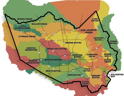
A watershed is an area of land that separates waters flowing to different rivers, basins or seas. Watersheds are usually named after the main body of water contained in them. For example, the Greens Bayou watershed contains Greens Bayou, the Cypress Creek watershed contains Cypress Creek, and so on. Watersheds are important because their surface water and storm water runoff end up draining into their respective bodies of water, which affects overall water quality. There are 22 watersheds in Harris County, as shown on the map to the right. Rather than analyzing specific cities, towns, or subdivisions, it's easier to look at watersheds. The Addicks Reservoir, Brays Bayou, Buffalo Bayou, Greens Bayou, and White Oak Bayou watersheds are larger, more populated, and historically more prone to excessive rainfall than the other watersheds. [4] [42]
Harris County Flood Control District [39]
In general, Harris County's soil is clay-like, so when it rains, instead of being absorbed into the ground, the majority of water creates storm water runoff. Additionally, because many parts of Harris County are urbanized, concrete pavements create a lot of run off as well.
Addicks Reservoir
Population: 295,694
Bodies of water: Bear Creek, Horsepen Creek, Langham Creek, South Mayde Creek
Cities: Addicks
Average yearly rainfall: 46.53 inches
Bodies of water: Bear Creek, Horsepen Creek, Langham Creek, South Mayde Creek
Cities: Addicks
Average yearly rainfall: 46.53 inches
Brays Bayou
Population: 722,716
Bodies of water: Brays Bayou, Keegans Bayou, Willow Waterhole Bayou
Cities: Bellaire, West University Place, Houston*
Average yearly rainfall: 46.24 inches
Bodies of water: Brays Bayou, Keegans Bayou, Willow Waterhole Bayou
Cities: Bellaire, West University Place, Houston*
Average yearly rainfall: 46.24 inches
Buffalo Bayou
Population: 444,602
Bodies of water: Buffalo Bayou
Cities: Houston*
Average yearly rainfall: 54.42 inches
Bodies of water: Buffalo Bayou
Cities: Houston*
Average yearly rainfall: 54.42 inches
Greens Bayou
Population: 397,748
Bodies of water: Garners Bayou, Greens Bayou, Halls Bayou, Reinhardt Bayou
Cities: Humble, Aldine
Average yearly rainfall: 44.87 inches
Bodies of water: Garners Bayou, Greens Bayou, Halls Bayou, Reinhardt Bayou
Cities: Humble, Aldine
Average yearly rainfall: 44.87 inches
White Oak Bayou
Population: 433,250
Bodies of water: White Oak Bayou, Little White Oak Bayou, Brickhouse Gully, Cole Creek, Vogel Creek
Cities: Houston*, Jersey Village, North Houston
Average yearly rainfall: 51.96 inches
Bodies of water: White Oak Bayou, Little White Oak Bayou, Brickhouse Gully, Cole Creek, Vogel Creek
Cities: Houston*, Jersey Village, North Houston
Average yearly rainfall: 51.96 inches
*Due to the size of Houston, it crosses over into multiple watersheds. However, the majority of Houston is in the Buffalo Bayou watershed.
Average yearly rainfall was calculated using data from 1996 to 2016 from a rain gauge contained within the watershed. For more details, please see our environmental analysis. Total Average Rainfall=48.80 inches.
Average yearly rainfall was calculated using data from 1996 to 2016 from a rain gauge contained within the watershed. For more details, please see our environmental analysis. Total Average Rainfall=48.80 inches.
